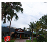
The fishery is located in the mountains of Huadong coastline, on the plain of East Rift Valley within the central mountain range. During the day, Pacific Ocean in the east is being heated, and water vaporizes. Being carried by the west wind, the vapor is being trapped inside the central mountain range. Hualien is famous for producing all kinds of ores, and these stones rich in minerals also act as a filter that purifies water. As a result, many natural springs are being modified into fish farming pools. Natural springs are pure with zero pollution. The first township after entering Hualien is the Shoufeng Township. It is the home to pure land and spring in eastern Hualien. ӤLichuan fisheryӯ is renounced as the pearl that shines inside natural springs. The purity of mountain and water could almost cleanse your mind and body.
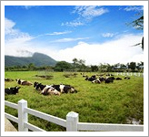
Ruisui farm is located in Wuhe Village of Ruisui Township. The farm produces dairy products for the Ruisui. The water here is clean and air is fresh, and so the dairy cows here grow strong and healthy. The milk they produce are highly delectable. Now that Ruisui farm operates in multiple businesses. Facilities like tourist center, outdoor cafe, and bike lanes are now available to visitors. The farm also supplies fresh dairy products to visitors. You are welcome to visit with your family to Ruisui farm and spend a splendid golden holiday.
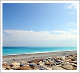
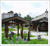
Chihsingtan scenic area is located in Xincheng township of Hualien. It is the only national scenic areas in Hualien. This place is mainly supported by bike lanes, which pass through Nanbin park, Hualien harbor, Siba highland and finally Chihsingtan beach. The bike lane extended to 21km long, and supported by essential facilities.
In Chihsingtan beach during the day, you can see the beauty of a crest shaped bay. However, at nighttime you can see dim lights blink in a distance from Xincheng and Chongde district. Same area at different times of the day offers you the top class sightseeing enjoyment.
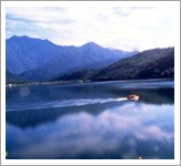
The lake is located in the Shoufeng township of Hualien. The lake area itself takes up a total of 104 hectares, and its vertical landscape formed a huge long oval. It is the largest inland lake in eastern Taiwan. The lake is surrounded by highways with a length of 5km. Visitors may ride here by bike to enjoy a healthy and pleasant holiday with lots of oxygen. Since 2002, Liyu Lake has been managed by East Rift Valley National Scenic Area Administration Management Office. Through detailed planning and design, management office offers recreational facilities such as water bike, boat, forest hiking trails, etc. The water of Liyu Lake endlessly emerges from underground, and the beauty of nature changes with each passing season. This charming lake attracts many visitors every year.
The park has an area of 11 hectares. It was an air force base of Japan during the war. In 1985, Hualien provincial seedling nurturing garden moved here. Originally this place was a wasteland of wilderness with forest and land of rock and sand. Through cultivation and management, soil is being improved to become suitable to cultivate seedlings. It became a major base for forest nurturing and county environmental improvement. In the year of 2000, the seedling nurturing garden started a new planning for Nanpu green forest park. In the year of 2005, provincial government held a renaming event for the park. The name ӤZhikaxuan Forest Parkӯ, originated from the culture of Amis tribe, and has been elected by a majority of votes. ӤZhikaxuanӯ is a term in Amis language. It is the old name for Jian township, meaning Ӥmany wood logsӯ. ӤZhikaxuan forest parkӯ combines nature and culture, and acts as a recreational and educational area for the community. It is also a famous point of interest for sightseeing in Hualien.
Pine Garden was built between 1942 and 1943. It was the military office of Japanese military during the war. The pine forests of the nearby Ӥbroadcasting centerӯ (now BCC Hualien), ӤCoastal radioӯ (now Chunghwa Telecom), and water work (Simeilun water purification company) lined up as a whole. At that time it was a major structure to Meilun Mountain. This garden during the time of Japanese colonization was a clubhouse for high-ranking military officer. Rumors said that Kamikaze squad force were granted a Ӥroyal wineӯ by the emperor before their mission. Pine Garden is located on the right side of Hualien Meilun Mountain behind the Central Mountain range and faces the Pacific Ocean. Other than the impressive constructions, the most obvious landmark is the pine tree forest of over 60 pine trees. The forest looks like a huge umbrella, decorated by a blue ocean and a tranquil sky to form a truly romantic sight. Other than pine trees, many other local native plants grow in the area such as parasol leaf tree, fern, silver grass, fig plants, etc. Among them, fig plants grow in a unique way. These Chinese banyans extend through cement walls, and to the inner structure of the building. In addition, the Meilun mountain area was once a coastal forest with rich soil. Because of colonization and immigration, people brought in different species of plants from other places. Because this place has been abandoned for more than a decade, local plants have dominated the area. This ecological system, with its rich number of species and their relation with natives are topics worth to be researched and observed.
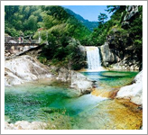
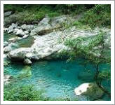
The Jade Valley Old Trail has been used 200 years ago. The trail follows along Mugua stream and some nameless sub-streams. It was the main trail that the Taroko tribe used to migrate from central mountain range to Mugua upstream (now Tongmen village). The route along offers a nice view with a trail that follows the streams. Yixiantian Valley also has ammunition storage and copper mine left by Japanese military police from the ӤLifanӯ period. At first the facility was used for irrigation. ӤJian plainӯ can still operate even now. It is a pleasant sightseeing area for tourists who interested in ecosystem, historic monuments, and scenic view. Jade Valley Old Trail routes are full of cliffs and small paths. Supported by local villagers, provincial government decided to rebuild the valley into a point of interest for visitors that love nature and history. Following the river valley going upstream leads to a nameless stream trail. The stream water is so clear that the riverbed can be seen. Water flows through the rocks and shines brightly in the valley. Visitors can see the Tongmen tribe from afar, and enjoy in the bliss of leaving everything behind while out in nature. Somewhere in the middle of Jade Valley is a sand dam. Pillars of water splash down from the dam. The water at this scenic point is good for sightseeing and swimming. At the destination a waterfall can be seen up in the mountains, with fish swimming freely below.
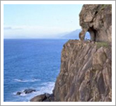
Cingshui Cliffs is a route located along the Suhua highway between Heren and Songde. The distance is about 12km. This snake-like route is also along coastal cliff. The scenic view is dangerous but magnificent. It is the most beautiful place of Suhua Highway, and also known as one of the eight greatest natural sights in Taiwan. After passing through the Heping Tunnel, this road, that seemingly hangs in the air, can be seen in all its beauty. Multiple layers of cliff and precipice are connected to each other. Gneiss and marble rocks can be seen on the route. Its magnificent views of nature are truly inspiring.
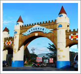
”u„ߤtŗ®³õ”v¦ģ©~ŖįŖF®ü©¤¤sÆß”A»P¤¤„”¤sÆ߶”ŖŗĮaئ„ģ¤W”F„Õ¤Ń”AŖF°¼Ŗŗ¤Ó„¬vØü¼ö¦Ó¤W¤ÉŖŗ¤ō»]®š”Aøg§j©Ų¦čÄĘ”A¦A³°ÄņØüŖż¾®»E©ó°ŖĮqŖŗ¤¤„”¤sÆߤsÄS”AĄH§Y«Bøض׻E¦ØŖe”A©ĪŖF¬y¤J®ü”B©ĪØI„ń¦a¤U¦Ø¬u”A„[¤WŖį½¬²±²£¦UĆžÄq„Ū”A³oØĒ„ŪĄY¤]Øć¦³¹LĀoŖŗ®ÄŖG”A©Ņ„H¶}Ęw„XŖŗ¤@ÓӤѵM“é¬u¾i“Ž¦Ą”A¬u¤ō¼ä²bµL¦Ć¬V”Aŗ”·ø¦Ó„XŖŗ¤ō”A¦AÄ~ÄņØä»õøU¦~ØÓ¤£ÅÜŖŗŖF¬yøōµ{”C¤jŖį½¬¶i¤JŖįŖFĮaئŖŗ²Ä¤@Ó¶mĀķ”Š¹ŲĀ׶m”A¬OŖįŖF²b¤gŖŗ²M¬u¤§¶m”A ”u„ߤtŗ®³õ”v §ó¬O°{Ä£©ó¬u¤ō¤¤Ŗŗ©śÆ]”A¤s²M¤ōØq”A„iŗ°¹ŠÄŪ”C
·ēĮJŖŖ³õ¦ģ©ó·ēĮJ¶m»RÅb§ų”AŖŖ³õ¬°·ēĮJ¶m¹T¹A°Ļ”A¦¹¦aŖŗ¤ō·½¬Ū·ķ¼ä²b”BŖÅ®š·sĀA”A¦]¦¹©Ņ¹}¾iŖŗØŤūĄYĄY§§ŗÓĀ×ŗ””A¤ū„¤¤]«D±`¦n³Ü”C ²{¤µŖŗ·ēĮJŖŖ³õ”A¤w“Ā¦h¤øŖŗ¤č¦VØÓøgĄē”A¶é¤ŗ¤£¦ż³]¦³¹C«Č¤¤¤ß”BÅS¤Ń©@°Ų®y”B¦Ū¦ęØ®¹Dµ„³]¬I”AŖŖ³õ¤]“£ØŃ·sĀAŖŗ¤ū„¤»s«~”AØŃ¹C«Č¹„Ī”AÅwŖļ±zÄā®a±a²²¤@¦PØÓØģ·ēĮJŖŖ³õ”AØÉØü¦³½ģŖŗ¶ĄŖ÷°²“Į”C
¤C¬P¼ę·“ŗ°Ļ¦ģ¦bŖį½¬æ¤·s«°¶m”A¬OŖį½¬æ¤°ß¤@Ŗŗæ¤ÆÅ·“ŗ°Ļ”A¦¹¦a„H¦Ū¦ęØ®¹D¬°®Č¹C°Ź½u”A³~øg«nĄŲ¤½¶é”BŖį½¬“ä”B„|¤K°Ŗ¦aØģ¤C¬P¼ę·“ŗ°Ļ”AŖų¹F¤G¤Q¤@¤½Ø½”A¦³µŪ¦U¶µµwÅé³]¬I”C ¦b¤C¬P¼ę”A„Õ¤Ń”A±z„i„H¬ŻµŪ®ü®lĄu¬üŖŗ©·§Ī®üĘW”A¤]„i„H»·²·²M¤ōĀ_±V”A©]±ß”A·s«°»P±R¼w¦a°ĻŖŗæO¤õĀIĀI”A¦P¼ĖŖŗ¦aĀI”A¤£¦PŖŗ®ÉØč”Aµ¹±z³Ģ³»ÆÅŖŗµųıÅT®b”C
ĆU³½¼ę¦ģ©óŖį½¬æ¤¹ŲĀ׶m”A“ņŖŗ±æn¬ł104¤½³¼”A±æn¼s¤j§e«n„_ÆUŖųŖŗ¾ņ¶ź§ĪŖ¬”A¬OŖF„xĘW³Ģ¤jŖŗ¤ŗ³°“ņŖy”A¼ęŖŗ„|©P¬°Ąō¼ę¤½øō”A„žµ{¬ł5¤½Ø½”A¹C«Č„i„HØÓ¦¹ĆM¼¦Ū¦ęØ®”AØÉØü°·±d¦³®ńŖŗ“r®®°²“Į”C ¦Ū„Į°ź91¦~°_”A”uĆU³½¼ę”v«K„ŃŖįŖFĮaئ°ź®a·“ŗ°ĻŗŽ²z³B±µŗŽ”Aøg¹L³W¹ŗ»P³]p”AŗŽ²z³B¦b¦¹“£ØѤF¤ō¤Wø}½ńØ®”B·Ę²ī”B“ĖŖLØB¹D…µ„¦h¤øŖŗ„š¾Ķ¬”°Ź”AĆU³½¼ęŖŗ“ņ¤ō¦Ū¦a©³“é„X”A²×¦~¤£ŗÜ”AĄu¬üŖŗ“ŗ¦ā”AĄHµŪ©uø`ÅܤĘøU¤d”A¹Ś¤ŪÆėŖŗ„P¹Ņ”A§l¤Ž³\¦h¹C«Č«eØÓ”C
„»¤½¶é¦ū¦a11¤½³¼”A¤éŖv®É“Į¤§ŖÅx°ņ¦a”A„Į°ź¤C¤Q„|¦~¶””AŖį½¬æ¤¬F©²]®E¾E©ó¦¹”Aģ¬°Æī³„ĀųŖL”BØF„ŪÄt¦a”Aøg¶}¾ĮøgĄē”B§ļØ}¤gÄ[”A°öØ|“Ó®ā]¤ģ”A¦Ø¬°„»æ¤„ž„Į³yŖL”B«°¶mŗń¬ü¤ĘŖŗ«n°ņ¦a”C„Į°ź¤K¤Q¤E¦~”A]®EĀą«¬”A®i¶}«n®Hŗń“ĖŖL¤½¶é¾ćŖvpµe”C „Į°ź¤E¤Q„|¦~”A椩²¬°„»¤½¶éĮ|æģ«·s©R¦W¬”°Ź”AŖü¬ü±Ś¤å¤Ę·N²[Ŗŗ”uŖ¾„d«Å“ĖŖL¤½¶é”vĄņ¦h¼Ę¤H«C·ż¦Ó„H¦¹©R¦W¤§”C”uŖ¾„d«Å”v”AŖü¬ü±Ś»y”A¦N¦w¶mĀĀ¦W”A”uĮ~§÷¬Ę¦h”v¤§·N”C”uŖ¾„d«Å“ĖŖL¤½¶é”vµ²¦X¦ŪµM»P¤H¤å”A¬°ŖĄ°Ļ«Ųŗc„š¾Ķ¤Ī±ŠØ|³õ°ģ”A¤]¬°Ŗį½¬¼W²K¤@³B¤£¦P·»ŖŖŗĘ[„ś“ŗĀI”C
ŖQ¶é§OĄ]¬ł«Ų©ó1942-1943¦~”A¬°¤éx”u§LØĘ³””væģ¤½«Ē”A»PŖžŖńŖŗ”u©ń°e§½”v”]²{¤¤¼s¤½„qŖį½¬„x”^”B”u®ü©¤¹q„x”v”]²{¤¤µŲ¹q«H”^”B¦ŪØÓ¤ō³õ”]¦ŪØÓ¤ō¤½„q¬ü±[²b¤ō³õ”^µ„¬Ņ¦³ŖQŖL³s¦Ø¤@¤ł”A¬°·ķ®É¬ü±[¤s«n«Ųæv”C¦¹¶é¦b¤éŖv®É“Į“æ¬O°ŖÆÅx©x„š¾Ķ©Ņ”A¶ĒØ„¤é„»Æ«·ÆS§š¶¤„X©ŗ®É¤]·|¦b¦¹±µØü¤Ń¬Ó½ą½ēŖŗ”u±s«e°s”v”A¼W²K³\¦h·Q¹³ŖŶ””CŖQ¶é¦ģ©óŖį½¬¬ü±[¤s„k°¼”AIµŪ¤¤„”¤sÆß”A±¦V¤Ó„¬v”A°£¤F«ŲævŖ«„O¤H¦L¶H²`Øč„~”A³Ģ©śÅćŖŗ“N¬O60 ¾l®č¤j¤łŖŗŖQŖL”A¹³ŗń¦ā¤j³ŹÆė¼µ°_”A»P½«ĀÅŖŗ®ü©¤”B¹ēĄRŖŗ¤ŃŖŧĪ¦Ø®öŗ©·±””C³oøĢ°£ŖQ¾š¤§„~”A©|¦³³\¦hģ„Ķ“ÓŖ«ŗ©„Ķ”A¹³¦å®ä”Bæ¹Ćž”BØ~Æó”Bŗ_ÄŻ“ÓŖ«µ„”FØ䤤ŗ_ÄŻ“ÓŖ«ŖŗÄń°Ē²{¶H³ĢÆS®ķ”A¦UŗŲ¤j¤pø³¶ŗ_¬ļ¹L¤ōŖdĄš”A ¦ł¤J«ŲævŖ«¤ŗÄ~Äņ½Æ©µ”C„t„~”A¬ü±[¤s¤@±aģ¬°ĀדIŖŗ®ü©¤ŖL”A„Ń©ó²¾„Į©M“Ž„ĮŖŗ®É„N”A±aØÓ¤F„~ØÓŖŗ“ÓŖ«”A¤]„Ń©ó¦¹¦a¶¢øm¤Q¾l¦~”Aģ„Ķ“ÓŖ«¤SZ²±°_ØÓ”A¦]¦¹ØäĀדIŖŗ“ÓŖ«„ĶŗA»P±ŚøsŖŗĆö«Yȱo¬ćØs”C
²M¤ōĀ_±V«üŖŗ¬OĬŖį¤½øō©M¤Æ¦Ü±R¼w¤§¶””AŖų¬ł12¤½Ø½Ŗŗøō¬q”C¦¹¬q¤½øō»dć馱§é”BĮ{±V¹G©¤”A“ŗĘ[ÅåĄI§§ÄR”A¬O¾ćÓĬŖį¤½øō¤W³Ģ¬üŖŗ¦a¤č”A³Q¦C¬°„xĘW¤K¤j©_“ŗ¤§¤@”C„un¹L¤F©M„ĄG¹D”A“N„i¬ŻØ£³oÄa¦b„bŖŤ¤Ŗŗ¹Døō”A¼h¼hŖŗÄa±V©M®k¾Ą¬Ū³sµŪ”C¤@øō¤W”A„ž³£¬O¤ł³Ā©„©M¤j²z©„”A§§ĮļŖŗ“ŗĘ[„O¤H·PØģ·q¬Č”C Ø«¦b³o¤½øō¤W©Ī³\¤£·|ı±o®`©Č”A¦ż¬O·ķØ«§¹¤F³o±ųøō”A¦^ĄY±ę®É”A¤~Åé·|Øģ³o¤@øō¤WŖŗĄI¹Ņ”C


![ŖQ¶é§OĄ]](images/p6.jpg)
![„ŪĄJ³ÕŖ«Ą]](images/p11.jpg)